Cairn Gorm, Highland, Scotland, UKi
| Regional Level Types | |
|---|---|
| Cairn Gorm | Mountain |
| Highland | Council Area |
| Scotland | Country |
| UK | Country |
This page is currently not sponsored. Click here to sponsor this page.


Latitude & Longitude (WGS84):
57° 6' 59'' North , 3° 38' 42'' West
Latitude & Longitude (decimal):
Type:
Köppen climate type:
Nearest Settlements:
| Place | Population | Distance |
|---|---|---|
| Aviemore | 3,150 (2017) | 14.0km |
| Boat of Garten | 517 (2012) | 16.3km |
| Nethy Bridge | 660 (2017) | 16.5km |
| Grantown on Spey | 2,440 (2017) | 23.9km |
| Kingussie | 1,450 (2017) | 24.9km |
Mindat Locality ID:
2879
Long-form identifier:
mindat:1:2:2879:3
GUID (UUID V4):
0aca9bf9-536f-489d-bd3b-0e3af0c4f847
Other/historical names associated with this locality:
Banffshire
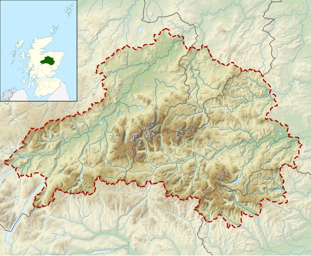
Cairn Gorm (Cairngorm) (Gaelic: An Càrn Gorm, meaning Blue or Green Hill) is a mountain in the Scottish Highlands overlooking Strathspey and the town of Aviemore. At 1245 metres (4084 ft) it is the sixth-highest mountain in the United Kingdom. It has given its name to the whole range, although these hills were historically known as Am Monadh Ruadh (the Red Hills) rather than the Cairngorms. Cairn Gorm is the most prominent of the Cairngorm mountains in the view from Aviemore, but it is not the highest.
600 ha of the north-western slopes of the mountain have been developed since 1960 for downhill skiing, in Coire Cas and Coire na Ciste. In 2001 a funicular railway was constructed to provide access through Coire Cas to the Ptarmigan building at 1087 m on Cairn Gorm.
The corrie south of Coire Cas, Coire an t-Sneachda, is separated from the skiing area by a ridge known as Fiacaill a' Choire Chais. The southern side of Cairn Gorm overlooks the remote loch known as Loch Avon (pronounced Loch A'an).
Select Mineral List Type
Standard Detailed Gallery Strunz Chemical ElementsDetailed Mineral List:
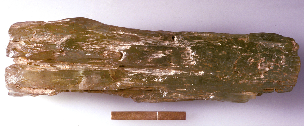
| ⓘ Quartz Formula: SiO2 References: |
| ⓘ Quartz var. Amethyst Formula: SiO2 |
| ⓘ Quartz var. Smoky Quartz Formula: SiO2 |
| ⓘ Topaz Formula: Al2(SiO4)(F,OH)2 References: |
Gallery:
List of minerals arranged by Strunz 10th Edition classification
| Group 4 - Oxides and Hydroxides | |||
|---|---|---|---|
| ⓘ | Quartz var. Amethyst | 4.DA.05 | SiO2 |
| ⓘ | 4.DA.05 | SiO2 | |
| ⓘ | var. Smoky Quartz | 4.DA.05 | SiO2 |
| Group 9 - Silicates | |||
| ⓘ | Topaz | 9.AF.35 | Al2(SiO4)(F,OH)2 |
List of minerals for each chemical element
| H | Hydrogen | |
|---|---|---|
| H | ⓘ Topaz | Al2(SiO4)(F,OH)2 |
| O | Oxygen | |
| O | ⓘ Quartz var. Amethyst | SiO2 |
| O | ⓘ Quartz | SiO2 |
| O | ⓘ Quartz var. Smoky Quartz | SiO2 |
| O | ⓘ Topaz | Al2(SiO4)(F,OH)2 |
| F | Fluorine | |
| F | ⓘ Topaz | Al2(SiO4)(F,OH)2 |
| Al | Aluminium | |
| Al | ⓘ Topaz | Al2(SiO4)(F,OH)2 |
| Si | Silicon | |
| Si | ⓘ Quartz var. Amethyst | SiO2 |
| Si | ⓘ Quartz | SiO2 |
| Si | ⓘ Quartz var. Smoky Quartz | SiO2 |
| Si | ⓘ Topaz | Al2(SiO4)(F,OH)2 |
Other Databases
| Wikipedia: | https://en.wikipedia.org/wiki/Cairn_Gorm |
|---|---|
| Wikidata ID: | Q1025927 |
Other Regions, Features and Areas containing this locality
British and Irish IslesGroup of Islands
Eurasian PlateTectonic Plate
EuropeContinent
UK
- Scotland
- Cairngorms National ParkNational Park
This page contains all mineral locality references listed on mindat.org. This does not claim to be a complete list. If you know of more minerals from this site, please register so you can add to our database. This locality information is for reference purposes only. You should never attempt to
visit any sites listed in mindat.org without first ensuring that you have the permission of the land and/or mineral rights holders
for access and that you are aware of all safety precautions necessary.


Cairn Gorm, Highland, Scotland, UK