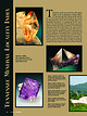
 | | Journal (article/letter/editorial) | | Tennessee Mineral Locality Index 300 T ennessee covers an area of 41,220 square miles in the southeastern...part of the state. Just prior to crossing the Tennessee River and continuing through the middle of the...Knoxville, Tennessee 37921 taparis@msn.com Figure 1 (top left). Calcite, 5.5 cm high, Elmwood mine, Smith...Smith County. Terry Huizing specimen, Jeff Scovil photo. Figure 2 (above). Fluorite, 13.1 cm wide, Elmwood...Elmwood mine, Smith County. Francis Benjamin specimen, Jeff Scovil photo. Figure 3 (left). Fluorite, 2.5 cm |  | | Book | | Mines SP Mining and Mineral in the South-Central] Operations States B80TIAT(G ge’ MINING AND MINERAL...cataloged as follows: United States. Bureau of Mines. Mining and mineral operations in the South-Central States:...and nonmetallics. Stable and economic domestic mining, mineral, metal, and mineral reclamation industries...enjoy your experiences. This pamphlet, a guide to mining and mineral operations that may be observed or...aid tourists and students who are interested in mining. Some may wish to study our Nation’s romantic past; |  | | Report (issue) | | Director For additional information write to: District Chief U.S. Geological Survey 520 19th Avenue Tuscaloosa...Organization of the Alabama District................................. District Chief's Office...................................................... 77 County Reports..........................................objectives of the Survey; organization of the Alabama District; sources of funding; current projects; hydrologic...These studies are in cooperation with municipal, county, State, and Federal agencies. The purpose of this |  | | Book | | volume is dedicated is four-fold: (1) To locate by mine, deposit, or community those mineralized areas of...offer the residence address of each collector by city and state through which contact may be faciliated...ALEXANDER CITY, Tallapoosa Co., (near) ClIALCOPYRITE ATTALLA, Etowah Co. H KMATITE BESSEMER, Jefferson Co...Hematite BIRMINGHAM, Jefferson Co. Hematite CALERA, Shelby Co. Wavkllite CLAY COUNTY, Sec. 24. T. 19 S R...Co., (W. border of* Marble Crystalline TALLADEGA COUNTY Marble, (crystalline) VALLEY HEAD, DeKalb Co. Hematite |  | | Report (issue) | | Daniel Kennedy, Regional Engineer Anthony Homyk, District Engineer *Certified Professional Geologist by...••• ••• ••• Geochronology Geophysics Hydrology Mine r alogy Str ucture • • • • • •• •• • • • • •...part of Marion County, Missouri: unpublished Masters thesis, Univ. of Iowa, Iowa City, Iowa, 1966. American...58, April 1966. Anonymous 1. The soils of Kansas City North (A general interpretation): U. S. Soil Conservation...and origin of sulfa-saline ground water, Saline County, Missouri, in Annual report, Water Resources Research |  | | Report (issue) | | scientific reports associated with the exploration, mining, and settlement of the western territories. The...natural features. Names like Chesapeake, Saginaw, Tennessee, Potomac, Shenandoah, Ohio, Kobuk, Taycheedah...populated place, locality, or civil division (city, village, or county) named for a physical feature is always...information is usually self-explanatory, for example: county seat. Feature Class (second column) The terms listed...their definitions. County (third column) This column lists the name of the county in which the entity |  | | Book (volume) | | vacation stops at a roadside “dig your own” gem mine. Junior finds a sapphire the size of a peach and...) Many an unsuspecting tourist has stopped at a mine to try his or her luck and become a rockhound for...VOLUME 4 Northeast States Connecticut Delaware District of Columbia Illinois Indiana Louisiana Maine...Island Missouri North Carolina South Carolina Tennessee Virginia West Virginia Vermont Wisconsin “...U.S.A. 4TH EDITION Where & How to Dig, Pan, and Mine Your Own Gems & Minerals VOLUME 2: SOUTHWEST STATES |  | | Book (volume) | | Mississippi, North Carolina, South Carolina, Tennessee, Virginia, and West Virginia VOLUME 3: THE NORTHWESTERN...Philadelphia, San Francisco, Washington London, Mexico City, Sao Paulo, Singapore, Sydney To one of the most...volumes, through very precise directions and accurate county maps, to get you to the best and most accessible...for the county in which it is located. This site number also appears under the given county in the text...pegmatite, shoreline, quarry, gravel pit, prospect, mine, etc.). Let’s take, as an example, under the heading |  | | Report (Issue volume) | | of nonfuel minerals and a chapter on trends in mining and quarrying in the metals and industrial mineral...State mineral production and mineral production by county were prepared in the Division of Statistics and...Dakota: South Dakota Geological Survey. Tennessee: Tennessee Division of Geology. Texas: Bureau of Economic... . . . . . . . . . . . . . . . . • . . • • • Tennessee, by Steve W. Sikich, Robert E. Fulweiler, and...which 329), which placed the collection of min- Mine Safety and Health Administration), eral statistics |  | | Report (issue) | | 1987 INTRODUCTION A significant proportion of mining industry's interest in the last few years has been...Bi-bearing skarns (Stormant) are known in the Moina Mining District, Tasmania, Australia, which is largely known...Gold Company; and Edward I. Bloomstein of Santa Fe Mining. GEOLOGIC DESCRIPTION Deposit type: Other Names:...metal-zoning relations constitute a local reversal of the district-wide zoning from Cu » Au » Ag, through Au + Ag...Fe-As-Zn-Cu-Bi-Au- and Sb-bearing ores at the Matsuo Mine, Japan (Matsukuma, 1962)) may be high-level reflections |  | | Report (issue) | | formation and cross section from Jackson County, Ind., to Floyd County, Ind. (line A-A'), showing relation...meager data available to him at that time. Numerous county sup plements to Logan's Subsurface strata of Indiana...A-A' is line of section shown in figure 4. 15 Jasper Co. 17 Coss Co. 30 Howard Co. 500' -- -- 51...at the be1 Two closely spaced test wells in Jay County appear as a single point. • CAMBRIAN AND ORDOVICIAN...Indiana Indiana Indiana Indiana Indiana Indiana County Berrien Cass Hillsdale Steuben De Kalb Kosciusko |  | | Journal (issue) | | MINING WORLD CATALOG, SURVEY & DIRECTORY NUMBER Blue Pages Pink Section Yellow Pages DIRECTORY INDEX...68 United States Mining in 1960 State-by-state report from and MINING to zinc Alaska to Wyoming...Shipments by mines for 1958, 1959, 1960 B96 Open Pit Mine Production ef 3 Technological ; Advances Tons...Tons mined and stripped & 99 Underground Mine Production from 1955 through 1960 > 101 Geology and...—==erererr Ofslo(Seep colitetol Mining Open Pit Mining World-Wide Mining Reports Africa-Asia-Caribbean-Europe |  | | Report (issue) | | Copies of this report can be purchased from: District Chief U.S. Geological Survey 2301 Federal Office...water-user ID number, water system name and address, county of operation, source of water (ground or surface...WATER DIST ADDRESS: P. 0. BOX 400 LOWELL 72745 COUNTY: BENTON SOURCE OF WATER: SURFACE WATER, BEAVER...NAME: GENTRY WATERWORKS ADDRESS: DRAWER C GENTRY COUNTY: BENTON SOURCE OF WATER: SURFACE WATER, FLINT CREEK...SEWER ADDRESS: 1101 WEST FRONT ST. HEBER SPRINGS COUNTY: CLEBURNE SOURCE OF WATER: SURFACE WATER, GREER'S |  | | Report (issue) | | 1982. The data are listed by aquifer, then by county. For additional information on the hydrologic...potentiometric-surface lows in Columbia, Union, and Jefferson Counties. The water-level hydrographs (figs....1982. 55 185 60 UJ O 11N02E26AAB1 Poinsett County 180 65 175 70 170 75 165 05 CM 05 80 160...160 O liCC CO O ~ 13N09E30CCD1 Mississippi County e 225 10 220 15 215 O H UJ O O UJ O 135...Arkansas County 130 O 125 x 8° £ 120 85 115 90 14S03W32BCD1 20 110 Chicot County 105 25 |  | | Book (edition) | | hard white rock or on unglazed porcelain. A MONET coy sisi 24 sis Visine OED ROO TOI TEsxe WEwaheeh ae...section. Limestone (dolomite) bluff near Jefferson City. It is determined as limestone with certainty...only polish or wear the metal slightly. Kansas City. THE COMMON ROCKS AND MINERALS OF MISSOURI ...crystal caves found in some mines in the Joplin district are accepted without question as mineral specimens...cavity filling in the rocks of the Joplin mining district and as a lining in cavities in the dolomitic |  | | Report (issue) | | 1983. The data are listed by aquifer, then by county. additional information reader is referred to...Ground-water resources of the El Dorado area, Union County, Arkansas: Arkansas University Bureau of Research...R. 0., 1961, Fresh-water aquifers of Crittenden County, Arkansas: Arkansas Geological Commission Water...and extent of ground-water supply of Mississippi County, Arkansas: Arkansas Geological Commission Water...level (feet) 1982-83 1979-83 Remarks ARKANSAS COUNTY 02S03W09DCD1 02S04W11DBB1 02S05W04BBB1 02S05W33DCD1 |  | | Report (issue) | | IDAHO So THIRTY - THIRD ANNUAL REPORT OF THE Mining Industry of IDAHO FOR THE YEAR 1931 STEWART INSPECTOR...submitted, STEWART CAMPBELL, Inspector of Mines. MINING 6 ARTICLES SPECIAL INDUSTRY APPEARING OF...32d, Bunker Hill & Sullivan M. & C. Co.: Valley County..---.....--.ee WA eee = 25th, ee ee ce ae BE UTS...AUD66 ee Oe ae ee es Dlectricity in Coeur d’Alene District: --...--...--..----...----------------- 30th,...Anaconda Copper Mining Ce.: Phosphate IME in ts. eee Stoping Anaconda Copper Mining Co.: Inclined Top |  | | Report (issue) | | Is EIN Mining Industry of IDAHO FOR THE YEAR 1928 UUUGEQEONGRGOUUEEEOOUOONGOUUOOGOQEOOOQOUVONOQO...EcIUUUGGMOUAN THIRTIETH ANNUAL REPORT OF THE Mining Industry of IDAHO FOR THE YEAR 1928 STEWART INSPECTOR...Sem OWNERSHIP STS VIS OF TIMBER ON UNPATENTED MINING 2 cere ee Ra ye pe a a RLECTRICIEY ON THE COURT...BBAR GIAKBS COUINT Yee cele ewe ds IBDN BEWAH. COUNTY 1M nook oe 0d ee a 0 ee ae ee ie yee IBUINGTRUAINE...ee BONNER (COUNTY. Ci. 0 ee es et ee BONUNB VAMGIEES (COUNTY 2.5 kool ee BOUNDARY: COUNTY. cis -t:50 |  | | Report (issue) | | 1985. The data are listed by aquifer, then by county. additional information on the hydrologic properties..."Remarks." 190 50 55 11N02E26AAB1 185 POINSETT COUNTY 60 180 65 175 70 ui 0 7* <-75 u_ 170 3 80...85 ui > ui < -i 13N09W30CCD1 UI MISSISSIPPI COUNTY w O UI 225 > CO 220 ui 215 ffi u. Z 15 of...uj 20 u o O 135 < 70 03S03W21ADD1 ARKANSAS COUNTY 130 80 125 85 120 90 115 i 1965 i i ... 1961 1965 02S05W34BDA1 ARKANSAS COUNTY 06S08W16CCC1 JEFFERSON COUNTY 1970 1975 1980 1985 Figure |  | | Report (issue) | | 1984. The data are listed by aquifer, then by county. For additional information on the hydrologic...LLJ O 65 11N02E26AAB1 < U_ CC 175 POINSETT COUNTY 70 170 CO Q Z < LLJ 75 165 LLJ 80 160 HI...HI CO LLJ CD 13N09E30CCD1 MISSISSIPPI COUNTY 225 HI > O a io 220 u_ ^ 15 215 5 70 135 ...I- I (- 80 03S03W21ADD1 Q. LLJ Q ARKANSAS COUNTY 85 120 90 115 1975 1976 1977 1978 1979...< U. QC D CO 17S15W18DBB1 320 (-135) UNION COUNTY (-140) 325 (-145) 330 Q 2 LU > LU (-150) |  | | Report (issue) | | parts of eastern Arkansas. In Arkansas, Columbia, Jefferson, Ouachita and Union Counties where withdrawals...1986. The data are listed by aquifer, then by county. For additional information on the hydrologic...of eastern Arkansas. In Arkansas, Columbia, Jefferson, Ouachita and Union Counties where withdrawals...cc CO Ul o > Ul < 80 02N08W30CAB1 LONOKE COUNTY r1 85 90 UJ a 95 Ul Ul 100 u. 105 110 Ul...I I I I I 1 90 11N02E26AAB1 185 POINSETT COUNTY 180 175 170 1 65 ui > UI 1 60 155 UI 00 UI |  | | Report (volume) | | concentration of metallic values from the ores of copper, zinc, lead, gold, silver, graphite, molybdenum, mercury...so successful. Allis-Chalmers Manufacturing Co. Mining Machinery Dept. OFFICES For Canadian MILWAUKEE...Canada THE MINES HANDBOOK Meeting tbe Needs of Mine and Smelter Hundreds of plants on both American...service from Superior Jaw Crusher Worthington mining equipment the from the standpoint of first cost...most wear, Worthington meets the needs of the mining industries with a complete line of products, from |  | | Report (issue) | | divisions, or any other cultural features (city, village, county, township, crossroad, and railroad siding)...appropriate variants. County (fourth column) This column lists the name of the county in which the entity... feature, or area lies in more than one county, the county listed is the one in which the center of...in the case of a stream, valley, or arroyo, the county listed is the one in which the mouth of the feature...EAST ALTHA WEST ALTURAS ALVA ALVA SE ALVA SW AMELIA CITY ANDYTOWN ANKONA ANNA MARIA ANTHONY APALACHICOLA |  | | Report (issue) | | THIRTY-FIRST ANNUAL REPORT OF THE Mining Industry of IDAHO FOR THE YEAR STEWART INSPECTOR CAMPBELL... a e ue THIRTY-FIRST ANNUAL REPORT OF THE Mining Industry of IDAHO FOR THE YEAR 1929 STEWART...HERCULES CUSTOM NEIL tee a ee es ee ANACONDA COPPER MINING Co.: INCLINED ToP SLICE STOPING IDAHO: PORTIAND::...INESWiEOTOTS, OF) SEDEG TAA IVITINGINGC Osteen tees MINE RESCUE. IN) PES CORWR DAU iN IRCCIDENTS) once...ANNUAL A TAG OUND Yi oe. ee ee Eee ot DR ADAMS COUNTY so secce tee ee ee be 1 IBANNOCK. (COUNIVY 3 ce |  | | Report (issue) | | 1. Map showing average water-level changes by county between 1982 and 1987 of wells completed in the... 3 Map showing average water-level changes by county between 1982 and 1987 of wells completed in the...presented in tables listed by aquifer; then by county. For each well, the depth to water below land...maps showing the average water-level changes, by county, between the years 1982 and 1987 for the aquifers...tables 1-16 and are listed by aquifer, then by county. For additional infor- mation on the hydrologic |
|


