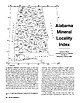
 | | Journal (article/letter/editorial) | | I I 34° MARIOH 34° I LAMAR , v:I G'l Alabama Q, \'l'I Q, 33° 0 1- I I I (/) ";lO ...Geological Survey of Alabama P.O. Box 0 Tuscaloosa, Alabama 35486 85° • County Seat ALABAMA'S MINERAL...iron furnace was built near Russellville, Franklin County, utilizing local brown iron-ore (goethite) deposits...Tennessee River Valley area near Huntsville, Madison County, the first such mineralogical description in the...the Coosa River (Chilton County). Utilization of mineral resources in Alabama has long been a significant |  | | Journal (article/letter/editorial) | | GRAPHITE DEPOSITS OF ASHLAND, ALABAMA? JOHN S. BROWN. CONTENTS. Introduction .....................themetamorphic rocks ................................ Graphite ...................................................... Massive graphite andgraphite veins ................................. Graphite inTalladega slate...belt. 2 Two areas,the moreimportantone entirelyin Clay • Society of EconomicGeologists,New York Meeting...Surv.of Alabama, •923, PP. t3, 98. 208 GRAPHITE DEPOSITS OF ASHLAND, ALABAMA. 209 County,the other |  | | Report (issue) | | Strategic Graphite A Survey By EUGENE N. CAMERON and PAUL L. WEIS CONTRIBUTIONS TO ECONOMIC GEOLOGY...___________________-__--_---__------__--____________ The graphite problem--__-_____-----------------_---_._____...occurrence of natural graphite._-_.._._.___ Minerals associated with various types of graphite.____________________...production.________________________ Geology of graphite deposits in the United States__-_._________--...deposits in carbonate rocks._________________ Graphite resources and reserves.__________________________________ |  | | Report (issue) | | technical in£onnati6n relative to· the p~oduetion of Graphite v?ill form a part of the volume• or volmne.s on...especially mica,, whicl1 is freque,n tly present in graphite- deposits. The useis of grapl1ite, aJ.~e n ume1"0...aphites in about equaJ p1·oportio11s. A flake graphite of l1igh graphitecontent may be useless for lubricating...the trade sense, and refers to that variety of graphite in which the particles are so fine as to give...special p~oses and of different v.alue. CeJ1lo11 graphite is sold a1s l11mp, ·chip and · .d ust., there |  | Defant, Marc J., Drummond, Mark S., Arthur, Jonathan D., Ragland, Paul C. (1988) An example of trondhjemite petrogenesis: the Blakes Ferry pluton, Alabama, U.S.A. Lithos, 21 (3) 161-181 doi:10.1016/0024-4937(88)90007-2 | Journal (article/letter/editorial) | | trondhjemite petrogenesis: the Blakes Ferry pluton, Alabama, U.S.A. MARC J. DEFANT I, MARK S. D R U M M O N...(U.S.A.) 2Department of Geology. University of Alabama at Birmingham, Birmingham, AL 35294 (U.S.A.) 3Department...trondhjemite petrogenesis: the Blakes Ferry' pluton, Alabama, U.S.A. Lithos. 21 : 161-181. The Blakes Ferry...pluton that is exposed in southwestern Randolph County, Alabama, U.S.A. The petrogenesis of the Blakes Ferry...location of the Blakes Ferry. pluton in the northern Alabama Piedmont. The numbers on the map refer to: (1) |  | | Journal (article/letter/editorial) | | trajectories: an example from the Northern Alabama Piedmont, USA RICHARD G. GIBSON & J . A . SPEER* Departmenr...Institute and State University, Blacksburg, V A 24061. USA Abstract. Contact aureoles of plutons emplaced into...than would be otherwise possible. In the Northern Alabama Piedmont of the southern Appalachians, Wedowee...this concept with an example from the Northern Alabama Piedmont of the southern Appalachians where rocks...the f-Tpath. GEOLOGICAL SETTING The Northern Alabama Piedmont of the allochthonous southern Appalachians |  | | Report (issue) | | aie! BARTLETT'S/27 FERRY FAULT } i GEORGIA ALABAMA sy .i % OP A iar an waeew ows mp ede eel (...CAROLINA ug 5; “A BARTLETT'S/.2 FERRY FAULT ? ALABAMA GEORGIA 50 . Lee 50 MILES SO KILOMETRES UNIVERSITY...this volume on the sulfide deposits of Georgia-Alabama. from does It has been the authors not involve...Appalachians in Paleorift the Southern Flank Alabama (Robert W. of Turkey Haven Schafer and J. Settings...Copper Anomaly at the Peachbottom Deposit, Alleghany County, North Carolina (John E. Callahan, J. Hatten Metal |  | | Report (issue) | | COLLABORATING STATE AGENCIES Geological Survey of Alabama, University, Ala. Department of :ty.lines, Mining...___ _ Resource potentiaL ____________________ _ Clay, by John W. Hosterman, Sam H. Patterson, J()hn W...Introduction __________________________ _ Miscellaneous clay and shale ____________ _ Types and occurrence ______________...______________ _ Resource potentiaL ________________ _ Fire clay _________ - _- _- - - - - - - - - - - - - - - -...potentiaL _____________ -_-Pottery and stoneware clay __________ ---Potassium-bentonite ________________ |  | | Book (volume) | | ............... xi Mineral Locations by State Alabama ....................................................................548 Table of Maps Page Alabama County Map .....................................................................................2 Alabama Stream Map ............................................................................4 Alaska County and Stream Map ......................................................................22 Arizona County Map .......................................... |  | | Report (volume) | | ......................................... 5 Alabama..................................................more extensive deposits of some others, such as clay, coal, and iron ore, are mentioned only in general...museum specimens. Some mineral aggregates, such as clay, granite, limestone, sand, and sandstone, are included...form. 10 USEFUL MINERALS OF UNITED STATES ALABAMA. ALABAMA. Alum. See Halloysite. Aluminum. See Bauxite...Bauxite and Halloysite. Asbestos. Tallapoosa County, with corundum deposits near Dudleyville; not found |  | | Journal (article/letter/editorial) | | t, aus aus- tus eixior in der Kahe befindlichen Mine liefert. - Der landischon Erzen 161 679 (189 122)...I'ennsylvanien und Alabama und besteht in dcm ,,flake"Graphit des Handels. I n Alabama beteiligten sich...die Ancnelda Graphite Co. u. Ashland Graphite Co. im Clay County und die Flaketown Graphite Co. im Chilton...Chilton County. I m Dezember hat eine neue Gesellschaft, die Jenning Graphite CO. in Lineville, 3 Meilen...Meilen nordlich von Ashland mit dem Abbau begonnen. -Von k ii n s t 1i c h c rn G r a p h i t hat die International |  | | Book (volume) | | .................v Mineral Locations by State Alabama .................................................rights, so remember you were told. If in doubt, a county map will tell you who the legal owner is. Good...Guide for Rock Hounds in the United States ALABAMA Alabama comprises two geological regions. The northeast...are exposed and commercially mined in Chambers, Clay, Cleburne, Coosa, Randolph, Tallapoosa, and parts...series includes granites, schists (mica, garnet, graphite, quartz), and gneisses, as well as numerous granite |  | | Book (volume) | | .................v Mineral Locations by State Alabama .................................................rights, so remember you were told. If in doubt, a county map will tell you who the legal owner is. Good...Guide for Rock Hounds in the United States ALABAMA Alabama comprises two geological regions. The northeast...are exposed and commercially mined in Chambers, Clay, Cleburne, Coosa, Randolph, Tallapoosa, and parts...series includes granites, schists (mica, garnet, graphite, quartz), and gneisses, as well as numerous granite |  | | Report (issue) | | occurrences of the Goldville District of Tallapoosa County, Alabama. Seven of the volume's papers deal with various...occurrences related to the Rockford Granite of the Alabama Northern Piedmont, the metallogeny of a central...Deposits, Goldville District, Northern Piedmont, Alabama (Harold H. Stowell and C. Michael Lesher)........in Auriferous Quartz Veins, Northern Piedmont, Alabama (Peng Sha and Michael Lesher)....................Geochemistry of Lode Gold Deposits, Northern Piedmont, Alabama (C. Michael Lesher, Harold H. Stowell, and Nathan |  | | Report (volume) | | Introduction 26 Construction Materials 26 Cement 27 Common Clay and Shale 28 Crushed Stone 28 Dimension Stone 29...Barite 49 Fluorspar 51 Garnet 51 Gem Stones 52 Graphite 53 Kyanite Group of Minerals 53 Phosphate 54 Rutile...the Knoxville 1oX 2° quadrangle, with State and county boundaries 2 2. Physiographic provinces of the...quadrangle 45 18. Areas containing resources of garnet, graphite, kyanite, quartz, rutile, sillimanite, and zircon...near the Knoxville 1oX 2° quadrangle by State and county 27 4. Recorded production of gold and silver from |  | | Report (volume) | | General features____________________________ Coosa County _________ ____________________ Randolph County...Cherokee County_____________________________ 72 Elbert County _____________________________ 75 Hall County__...County_______________________________ 76 Hart County. ___ __ __________________ 77, Lumpkin and Union counti...___________ S3 Pickens County _______-______________________ 83 Rabun County-_____________________________...____________ 86 Troup County ________________________________ 86 Upson County _______________________________ |  | | Book | | II: Where to Find Gems and Minerals in L.\merica Alabama Alaska Arkansas Arizona California Colorado Connecticut... limestone (and/ or sandstone), marble, and the clay minerals for baking into ceramics and pottery or...had been sending great expeditions to prospect and mine for it throughout the Sinai Peninsula since at least...and abandoned, one is also sure to find extensive mine dumps sloping steeply down from the shaft or tunnel...prodvced by atmospheric oxidation, can be found. Old mine dumps often reveal a varied assortment of brightly |  | | Report (issue) | | _________________ _ Wedowee formation ____________________ _ Ashland mica schist ____________________ _ Volcanic series...Georgia ___________________________________ _ Alabama __________________________________ _ Younger rocks...34 35 35 36 39 44 44 45 46 47 47 49 49 50 50 Mine descriptions ___________ --------- -- .. -------...___ _______________________ _______ _ Fauquier County ____ ______ ______ _____ _____ _ Franklin ____...properties _________ .. _____________ _ Halifax County ______ - _____ - __________ ~- _'- __ _ Virgilina |  | | Book | | ____________________ ..... CHAPTER 11 Georgia 1 CHAPTER 12 Alabama 0 0 . . . . . . . . _ 3 VI 1 1 1 1 2 9...was m e r e l y p a r t o f t h e waste o f t h e mine. W h a t t h e y needed was h i g h grade ore o...Newton, Wa l t o n , F a n n i n , F o r s y t h Alabama: C l a y, Cleburn, Coosa, Tallapoosa, C h i l t...i n , Dawson, Banks, Clayton, Lee, Tw i g g s Alabama: St. C l a i r , Lee, Shelby Pearls r a n k a s...e d S t a t e s w e r e t h e Tennessee a n d Alabama Rivers. N e w Jersey: L a k e Hopatcong, Greenwood |  | | Journal (volume) | | Lehigh University, South Bethlehem, Pa. Co., Graphite. Tungsten. v VI LIST OF CONTRIBUTORS Newland...Mansion House, London E. C., England. Garnet. Graphite in New York. Gypsum in New York. Tin. Sellards...Prouty, William F. Prof, of Geology, University of Alabama, Uni¬ versity, Ala. A. H. VON SCHLICHTEN, O....Broadway, New York, N. Y. Gold and Silver. Graphite in Alabama. PORDUE, Paso, Data of World’s Principal...has a State mineralogist, while Idaho has a State mine inspector who collects statistics of mineral production |  | | Report (volume) | | Group) ABGP01 1. Paleozoic 2. Alabama (NE) 3. Bearce, D. N., 1973, Alabama Geol. Soc. Guidebook 11, p....section: Abel Gap, on Alabama Highway 49 (Skyway Road) near town of Abel, Cleburne County. Absaroka Supergroup/Volcanic...volcanic field, Yellowstone National Park, Park County, Wyo. Academy Church Shale Member (Springer Formation)...W1/2NW1/4NE1/4SE1/4 sec. 1, T. 3 s., R. 2 E., Carter County. Adams Formation ADMS01 1. Holocene 2. Alaska (SE)...Univ. Inst. Polar Studies Rept. 25, p. 53-65 4. Clay, sandy silt, with intercalated clayey till 6. 66 |  | | Report (issue) | | locality, or civil division (city, village, or county) named for a physical feature is always listed...information is usually self-explanatory, for example: county seat. Feature Class (second column) The terms listed...their definitions. County (third column) This column lists the name of the county in which the entity...place, feature, or area lies in more than one county, the county listed is the one in which the center of...in the case of a stream, valley, or arroyo, the county listed is the one in which the mouth of the feature |  | | Book | | HfiRIN COUNTY FREE LIBRfiRY 311110G386652Q I V Russell P MacFal A COLOR TREASUF FOR COLLECTORS...it a veritable not just a picof informa- is mine tion, telling everything the collector needs to...to Hunting Locations ? i 9 GIVEN TO THE MARIN COUNTY LIBRARY BY MARI N L MTNF.RAT. SOCTETY DAVID...can use a mountaineering bag or a mili- quarry or mine where a permit tary bag; make it it should...may be able to buy specimens. map of Keweenaw County. Mich- Part of the U.S. Geological Survey topographic | | | Book | | not just a picture book. Rather, it is a veritable mine of information, telling everything the collector...you If you plan to vIsIt an operating quarry or mine where a permll Is required make the necessary arrangements...LAKE BAILEY N I DELAWARE MINE DUMPS IOATOUTE CHLORASTROUTEI 2 AMYGDAlOID MINE DUMPS 3 AGATE HARBOR (AGATES...(AGATES THOMSONITE ON BEACH\ )l MUD VLAKE TO MANDAN MINE - HARD SURFACE Field drawing to locate a collecting...topographic map of the Delaware q uadrangle o f Keweenaw County, Michigan This ,s an example o f the more picturesque |  | | Book (edition) | | ••••••••••••••••••••••••••••• UNtl'ED STATES Alabama ······························································...Guide and Prospecting Permit may NOT prospect or mine on GPAA listed claims or other property reserved...hard layer that acts like bedrock in trapping gold. Clay, volr.anic ash and caliche often serve as false...AIABAMA History I ,ike Georgia and North Carolina, Alabama had a "rush" of its own, following the discovery...discovery of gold in 1830 in oldAutauga (now Chilton) County along tributaries of Chestnut and Blue Creeks, |
|


