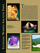
 | | Journal (article/letter/editorial) | | Tennessee Mineral Locality Index 300 T ennessee covers an area of 41,220 square miles in the southeastern...part of the state. Just prior to crossing the Tennessee River and continuing through the middle of the...TRAVIS A. PARIS 5604 Malmsbury Road Knoxville, Tennessee 37921 taparis@msn.com Figure 1 (top left). Calcite...Calcite, 5.5 cm high, Elmwood mine, Smith County. Terry Huizing specimen, Jeff Scovil photo. Figure 2...(above). Fluorite, 13.1 cm wide, Elmwood mine, Smith County. Francis Benjamin specimen, Jeff Scovil photo. |  | | Report (volume) | | 6 USEFUL MINERALS OF THE UNITED STATES. Tennessee........Mr. George H. Ashley, Washington, D. C...See Bauxite and Hallpysite. Asbestos. Tallapoosa County, with corundum deposits near Dudleyville; not found...commercial quantity or quality. Asphalt. Colbert County, small quantity has been shipped from near Leighton;...following localities: Bibb County, Pratts Ferry; Calhoun County, near Tampa; Clay County, T. 20, Pv. 7 E.; Jefferson...Jefferson County, at Elyton; Lee County, at Chewacla lime works; St. Clair County, at Gfeensport; Shelby |  | | Report (issue) | | Uranium occurrences in non-sedimentary rocks of Tennessee .......... 87 Table 16 Uranium occurrences in...Uranium occurrences in non-sedimentary rocks of Tennessee.....................................88 Figure...deposit occurs as a thin seam in graphitic Cleburne County. The property is, about 11.2 SINE phyllite which...Location No. Source of information Fairfield County. Short distance northeast of East Village, on a...beyond the old canal. Schairer, 1931. Fairfield County. Proceed up hill Cameron, et on Portland Ave. from |  | | Report (issue) | | and Mountain City Windows, North Carolina and Tennessee Mervin J. Bartholomew, Sharon E. Lewis, Joseph...17 III. The Cranberry magnetite deposit, Avery County, North Carolina P. G. Feiss, S. Goldberg, W. Ussler...granulite-facie Gneisses, Roan Mountain, North Carolina-Tennessee John R. Monrad and Gerald L. Gulley, Jr.. . ....41 V. Debris-avalanche type features in Watauga County, North Carolina Jeffrey J. Gryta and Mervin J....AND MOUNTAIN CITY WINDOWS, NORTH CAROLINA AND TENNESSEE Mervin J. Bartholomew Montana Bureau of Mines |  | | Report (volume) | | ............................................ Tennessee.....................^........................... Colorado, New Mexico, Oregon, South Dakota, Tennessee, and Texas; to list all the literature consulted...minerals of Tennessee, their nature, uses, occurrence, and literature: The resources of Tennessee, vol. 3...See Bauxite and Halloysite. Asbestos. Tallapoosa County, with corundum deposits near Dudleyville; not found...commercial quantity or quality. Asphalt. Colbert County, small quantity has been shipped from near Leighton; |  | | Report (issue) | | traced across Pennsylvania into Ohio. Many of the county and other geologic reports concerning the Pennsylvanian...been completed in Ohio. Additionally, all of the county geologic reports for the coal-bearing areas of...districts within the plateau. As a result of their county geologic reports, both Ohio (Bownocker and Dean...Kentucky, southwestern Virginia, and eastern Tennessee are partitioned by major mountain or ridge divides...Vv > Ss j a sore : NG - at ieee, RPSs TENNESSEE CAROLINA Za ¢/ Alabama bs el 3 |, PE Black |  | | Journal (issue) | | 995 00 complete Free shipping in continent USA Made in USA Grit Sizes 60 to 200,000 1.0" hole with...with 3/4", 5/8" & 1/2" bushings Our made in USA soft wheels will last you 3-4 times longer than imported...monthly meetings of clubs, including the South Orange County Gem & Mineral Society. Usually, Walt also uses...Oceanview Mine in the Pala region of San Diego County, California. Field trip participants can dig and...include zircon, phengite, monazite, kyanite, talc, paragonite, and vermiculite. Thanks to the zircon minerals |  | | Report (volume) | | uranium in the Lassen lavas is concentrated in zircon. 207 208 3 SELECTED BIBLIOGRAPHIES OF URANIUM...proportion of minor accessories (sphene, apatite, and zircon). Part of the uranium and thorium is interstitial...and secondarily by an increase in the amount of zircon. The rocks of the New Hampshire magma series of...certain accessory minerals of granite, such as zircon, allanite, sphene, and apatite. Much of the uranium...from the United States. The Carthage meteorite (Tennessee) and the Brenham Township meteorite (Kansas, iron |  | | Journal (article/letter/editorial) | | located in the Eureka Mining District in Yavapai County, Arizona. From this old mine we have a number of...They come from the Blue Creek Mt. Mine, Del Norte County, Calif., which I own. The ore of my mine is very...xls. "This is a section of a geode found in Brown County, in the vicinity of Bean Blossom, Indiana."—on...is it? Found on Stafford Ridge, near Carter City in Carter County, Ky." The streak is brown chert (quartz)...same Roefcs VVNCP MINERALS' black stuff in Smith County, Miss., near the mouth of Ichusa Creek on the bank |  | | Report (issue) | | Oklahoma A1 NEW MEXICO ^ OKLAHOMA ARKANSAS TENNESSEE EASTERN EDGE :OF CRETACEOUS ROCKS LOUISIANA ...workers (for example, Tanner, 1967; Walper, 1977; Carter, 1979; Booth, 1981; Haas, 1981; Axtmann, 1983)...significant lateral offset of this sand is required. Carter (1979) drew an isopach map for the Hunton Group...vertical. West side of Interstate Highway 35, Murray County, Oklahoma. Location of area shown in figure 10...107-120. Bowring, S.A., and Hoppe, W.J., 1982, U-Pb zircon ages from the Mt. Sheridan Gabbro: Oklahoma Geological |  | | Report (issue) | | OF THE FLINT MILL ROADLESS AREA, CARTER AND JOHNSON COUNTIES, TENNESSEE By K. A. Duttweiler, E. F. Cooley...in the Cherokee National Forest, Carter and Johnson Counties, Tennessee. The Flint Mill Roadless Area was...7,183 acres in the Cherokee National Forest in Carter and Johnson Counties, Tenn. The area consists entirely...the Cherokee National Forest in northeastern Tennessee. Its southern boundary is approximately 20 mi...of the area lies in Carter County and the northern one-fourth lies in Johnson County. The Roadless Area |  | | Journal (issue) | | WASHINGTON May 2, 2009 9:00 am to 5:00 pm Clark County P. U. D. Building 1200 Fort Vancouver Way Vancouver...Museum (MTMM) at Montana Tech. Analcime Carbon County: Sedimentary rocks, various locations - Frontier...Livingston Group - minor amounts (Roberts, 1963). Carter County: Sedimentary rocks, Ekalaka area - from lignite...(Denson & Gill, 1965; Sheppard, 1976). Garfield County: Igneous rocks, Smoky Butte (Velde, 1975; Mitchell...1987; Hearn, 1989b; Irving & Hearn, 2003). Fergus County: Igneous rocks, Judith Mountains (Weed & Pirsson |  | | Report (issue) | | radioactivity well logs from McCone County, Mont., to Butte County, S. Dak. 7. Correlation of radioactivity...radioactivity well logs from Roosevelt County, Mont., to Perkins County, S. Dak. 8. Map showing locations of...shale, Billings County, N. Dak. 10. Geologic map of the Little Badlands, Stark County, N. Dak. 11. Geologic...area, Slope County, N. Dak. 12. Geologic map and sections of the Slim Buttes, llarding County, S. Dak. 13...Buttes, Harding County, S. Dak. 14-17. Geologic map of: 14. Short Pine Hills, Harding County, S. Dak. 15 |  | | Journal (article/letter/editorial) | | October 2014 Mineral Index by Counties Alfalfa County Carmen, 2 mi. NE of Carmen, 1 .1 mi. W of Highway...Permian-age Crisfield Sandstone: malachite. Adair County Bunch, near Bunch, secs.l.5, 16, T.14N, R.24E:...fluorescent and phosphorescent) (Gilmore 1963). Beckham County Malachite localities, SW1/4 SE1/4 sec.36 and SE1/4...at Great Salt Plains, Alfalfa County. Joe Lobell photo. Blaine County Southard, quarries of the U.S...Gypsum, variety selenite, Great Salt Plains, Alfalfa County. Left, 12 cm high; center, 17.6 cm high; right |  | | Book | | Gives a sodium flame. Nearly insoluble. COMANCHE COUNTY: SE%, Sec. 4, T.3N., R.15W. The xtals are i to...side by granite, AGATE (See Quartz) CANADIAN COUNTY: South Canadian Rivers. In the gravel bars of...the Also in sand plant waste dumps. CIMARRON COUNTY: Secs. 7, 8, 9, 10; T.5N., R.2E. Cimarron Meredian...widely scattered in the Black Mesa area. DEWEY COUNTY: Agate is found 2 miles east of Seiling in the...at Taloga in the South Canadian River. HARPER COUNTY: Secs. 17, 20; T.27N., R.23W.. Jaspagate. Secs |  | | Report (issue) | | ____ Marble and limestone___________________ Tennessee marble belts______________ Virginia marble belts________________... Columnar sections of Pennsylvanian rocks in Tennessee and Kentucky____ 13. Tectonic map of the Appalachian...pinnacles beneath soil cover, Bluegrass, Highland County, Va_ _ _ _ _ _ _ _ _ _ _ _ _ _ _ _ _ _ _ _ _ _...transverse joints cutting shale at Poverty, Highland County, V a_ _ _ __ _ _ _ _ _ _ _ _ _ _ _ _ _ _ _ _ _...resources in Alabama, eastern Kentucky, Ohio, Tennessee, and Virginia according to thickness of beds |  | | Journal (article/letter/editorial) | | unweathered to highly altered. Tourmaline, garnet, zircon, rutile, and biotite were recognized in a few samples...sandstone at the base of the underclay Vermillion County, Indiana (outcrop 28), a contains about the same...underclay materials. However, For example, in Crawford County, Kansas the assumption that the sandstones have...outcrop of the Ravenscroft Coal in White County, Tennessee (zone 2, outcrop 21). The edge of a channel...illustrated by Figure 13c is in a clay pit in Holmes County, Ohio (zone 8, outcrop 5). Samples a and b are |  | | Report (issue) | | Upper Precambrian (?) or Lower Paleozoic (?) Stokes County and Kings Mountain belt Kings Mountain group Lower...relatively small area in the northwest corner of Ashe County. The Carolina Slate belt consists of volcanic-sedimentary...four areas, commonly referred to as the Stokes County area, the Kings Mountain area, the Brevard area...area, and the Murphy area. The rocks in the Stokes County and Kings Mountain areas are much alike and are...marble. These two areas are classed as the Stokes County and Kings Mountain belt. The other two areas are |  | | Report (issue) | | through Cranberry and about 6 miles west into Tennessee. The principal producing mine in this belt was...WINDOW AND VICINITY. NORTH CAROLINA mine to the Tennessee Stateline. One magnetic anomaly was drilled about...the Linville quadrangle and 6 miles west into Tennessee suggests that their present position is related...prospected in (1) heavy mineral partings rich in zircon in the clastic rocks of the Chilhowee Group in...lending and buying policies. For instance, Avery County produced about $186,000 worth of sheet mica in |  | | Journal (article/letter/editorial) | | thesis on the rare earth content o f the mineral zircon and described a new mineral, geerite, which has...23:46 07 August 2017 Left: Amber calcite, Carter County, Montana; 6.5 cm x 9 cm. Below: Pale green.... 1 9 7 1 . Mineral collecting in St. Lawrence County, geological studies of the Northwest Adirondack...G . 1979. Occurrence of Rare Earth Elements in Zircon. Ph.D. Thesis, Queen's University, Kingston, Ontario |  | | Report (volume) | | ge of the Hood Bay Formation, Alaska by Claire Carter --------Mount Lord Volcanics, Pima Country, Arizona...----------Six new members of the James Run Formation, Cecil County, northeastern Maryland, by Michael W. Higgins ...Arizona -----Generalized geologic map of Cecil County, Md., showing members of the James Run Formation... D.J.• , 1976, Geologic map of western Whatcom County, Washington: U.S. Geol. Survey Misc. Geol. Inv...Geologic map of the Milligan Lakes quadrangle, Park County, Colorado: U.S. Geol. Survey Geol. Quad. Map GQ-1343 |  | | Report (issue) | | Madison County, North Carolina By Steven S. Oriel Prepared in Cooperation with the Tennessee Valley Authority...Mineral Resources of the Hot Springs Window, Madison County, North Carolina." This bul letin is another in...being made possible by the cooperation of the Tennessee Valley Authority. The Hot Springs window is an...western part of Madison County, North Carolina, and easternmost Cocke County, Tennessee. It is roughly coextensive...detailed studies of similar rocks in eastern Tennessee. In addition to being of great scientific interest |  | | Journal (article/letter/editorial) | | Indian Queen mine ca. 1905 at Farlin, Beaverhead County. 208 ROCKS & MINERALS Downloaded by [University...mines at Butte in Silver Bow County and the Black Pine mine in Granite County have produced many fine crystal...Beaverhead County, the pegmatites of Jefferson County, and the Snowbird mine in Mineral County continue...Highlands Centennial Nugget in 1989 in Silver Bow County. The seventh largest gold nugget found in Montana;...should be sent to the author. LOCATIONS BY COUNTY Beaverhead County Anderson deposit, sec. 16, T. 12 S., R |  | | Report (volume) | | Proceedings, vol. 1, pts. 1-3. Staten Island, N. Y. Tennessee State Geological Survey; Bulletin nos. 25, 26...Virginia Geological Survey: County Reports, Nicholas County, Tucker County. Morgantown, W. Va. Wisconsin...30, 1921. 12. Geology of Lemieux township, Gaspe County, Quebec: Canada, Geol. Survey, Summ. Rept., 1921...Glacial geology [of the Mount Marcy quadrangle, Essex County, New York]: New York State Mus. Bull. nos. 229...23-24, 1 fig., September, 1920. Anderson, John Carter. 36. Ore deposits of the Pioche district, Nevada: |  | | Book (edition) | | mmed at Broken Arrow aud Trout creek, in Sc. Clair county. The strata in this field are more faulted und...prong of Canoe creek, in St. Clair county, to Ha\sop creek, in Bibb county, a distance of 60 miles. Down to...to Helena, in Shelby county, the field has an average width of 5 or 6 miles. Below that point the width...miles being in the latitud" of Blocton, in Bibb county. The south ern end of this field has a greater...Jefferson county; Helena, Montevallo, and Brierfield, Shelby county; and at Blocion. Bibb county. The Warrior |
|


