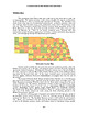
 | | Book (volume) | | vertebrate remains. The breaks of the White River north of Crawford in Dawes Co. and the rather extensive...chalcedony, jasper and gem petrified wood. BUFFALO COUNTY KEARNEY, area gravel bars and pits along the Platte...townagate, chalcedony, jasper, petrified wood. CASS COUNTY WEEPING WATER, SE, on rd. to Nehawka, in the Snyderville...chalcedony, jasper, fossils. CHERRY COUNTY VALENTINE, in the Sandhills county along the Niobrara R. and Minnechaduza...CHEYENNE, DEUEL, GARDEN & KEITH COUNTIES AREA, between North and South Platte rivers and in all tributary branches |  | | Book (volume) | | grading to 600 to 800 feet thick in the north. ALEXANDER COUNTY FAYVILLE, area stream gravels⎯agate, jasper...⎯agate, jasper; d RR siding of Clay⎯agate. CALHOUN COUNTY AREA, shores of the Mississippi R., in the Warsaw...crystals). CRAWFORD COUNTY PALESTINE, area deposits⎯Siderite. EDWARDS COUNTY AREA, T. 1 S, R. 10 E...E, regional deposits⎯Siderite. FULTON COUNTY FARMINGTON, W 6 mi. on Rte. 116 to the Rapatee No. 5 strip...mine⎯pyritized gastropods (Pennsylvanian age). GRUNDY COUNTY AREA: c Regional rd. and RR cuts and banks of Mason |  | | Book (volume) | | grading to 600 to 800 feet thick in the north. ALEXANDER COUNTY FAYVILLE, area stream gravels⎯agate, jasper...⎯agate, jasper; d RR siding of Clay⎯agate. CALHOUN COUNTY AREA, shores of the Mississippi R., in the Warsaw...crystals). CRAWFORD COUNTY PALESTINE, area deposits⎯Siderite. EDWARDS COUNTY AREA, T. 1 S, R. 10 E...E, regional deposits⎯Siderite. FULTON COUNTY FARMINGTON, W 6 mi. on Rte. 116 to the Rapatee No. 5 strip...mine⎯pyritized gastropods (Pennsylvanian age). GRUNDY COUNTY AREA: c Regional rd. and RR cuts and banks of Mason |  | | Book (volume) | | .......................................346 North Carolina ........................................................................................356 North Dakota ...............................................................................427 South Carolina ...............................................................548 Table of Maps Page Alabama County Map ...................................................................................4 Alaska County and Stream Map ............................... |  | | Report (issue) | | Geological Survey editorial standards or with the North American Stratigraphic Code. Any use of trade, firm...Spectrography; F-AA, Flameless Atomic Absorption; GF-AA, Graphite Furnace; Inst, Instrumental; ICPAES, Inductively-Coupled...Samples were analyzed for gold by a flameless graphite furnace (GF-AA) method (O'Leary and Meier, 1986)...codes: GF-AA-W Graphite furnace, western forest and surrounding areas (N=l 118) GF-AA-C Graphite furnace, north-central...north-central forest (suture zone) (N=219) NAA-E Neutron activation (Elk City NURE), eastern forest and |  | | Book (volume) | | .......................................295 North Carolina ........................................................................................302 North Dakota ...............................................................................366 South Carolina ................................................rights, so remember you were told. If in doubt, a county map will tell you who the legal owner is. Good...Cumberland Plateau and climaxing in 2,407 ft. Cheaha Mt. This crystalline or mineral region is composed primarily |  | | Book (volume) | | .......................................295 North Carolina ........................................................................................302 North Dakota ...............................................................................366 South Carolina ................................................rights, so remember you were told. If in doubt, a county map will tell you who the legal owner is. Good...Cumberland Plateau and climaxing in 2,407 ft. Cheaha Mt. This crystalline or mineral region is composed primarily |  | | Book | | York North Carolina North Dakota Ohio Oklahoma Oregon Pennsylvania Rhode Island South Carolina South...listed by county and community, range and distance. Whenever the collector crosses a county line, he will...of the county he is entering posted alongside the highway. By looking up the state and county, the user...guide can determine the collecting sites in that county by range and distance from the major cities and...information to reach a specific spot within a particular county. Many old localities listed here have, literally |  | | Journal (issue) | | Columbia United at Emmett States, St., Bristol, North Central at the Post Office at Bristol, St., Seattle...Company in every mining area of the world except North America, Australia and the Philippines, where they...Herbert and Lickfett, Corporation York 4, N.Y North A/B, Africa Stockholm 3, Sweden S.E.M. U., 3...Turkey Journals, Inc. SUBSCRIPTION RATES U.S. North, South and American Countries Other Countries Single...DIRECTORY & DIRECTORY Norway Portugal 5 AMERICA NORTH Contents may not be reproduced without permission |  | | Report (issue) | | 32d, Bunker Hill & Sullivan M. & C. Co.: Valley County..---.....--.ee WA eee = 25th, ee ee ce ae BE UTS...been kept up to date, and so far as is known, each county bibliography contains references to all material...importance that has ever been published concerning that county. Publications relating to specific minerals found...Fluorspar Pumice Antimony Fullers Earth Radium Arsenic Graphite Silica Sand Asbestos Gypsum Sodium Barytes Magnesium...black, graphitic lime shale beds near Lucile, Idaho County, continued to be used as a basis for exploiting |  | | Report (issue) | | ANNUAL A TAG OUND Yi oe. ee ee Eee ot DR ADAMS COUNTY so secce tee ee ee be 1 IBANNOCK. (COUNIVY 3 ce...ae en ee ee BEAR AK COUNTY tice cto os eee ee ee, ee a meee IBENEWAH COUNTY: 2.-. 5 2: SEAN eee ee...GOUNTY 2g) coe reese See NI re ee en en BiALNE (COUNTY 27 in8 5 See oe ee ok ee es eT ee ee ee RBOTS WsCOUNT...Yee csr dot letBy eae ea es ge Bay Re a BON NERS COUNTY Js Seer e ee 8 RE Peo ee ea et a et ee ee BONNEVILLE...eae, SeemNO a Ae el Burren COUNTY sok 2050 SE 5 oe ee eg a ee el GAM AS COUNTY 5-0-2520: te Bes ee aaa | |  | | Journal (issue) | | and cord · :::, ready to run . ":-.! MINI-SONIC ® MT-4S COMPACT TUMBLER 175-55 $12.95 Extra hopper 5...Mrs Peg Norton. President 11945 Magnolta Blvd . North Hollywood, CA 91607 Lee Holhnshead. First V1ce-Pres1den1...Wallace. V,ce-Pres1den1 636 Burltngton, Billings. MT 59102 Mrs Helen Swearingen. Secretary PO Box 74,...State street In downtown Carlsbad, Calif. (Outside USA send $2.00 for catalOC) GEMS & MINERALS - 7 KEIJIJY...Springs near the tiny village of Magdalena, Socorro County. No notable production resulted, but this discovery |  | | Report (issue) | | IBANINOCK COUNTY i xcec2 oh cccen eke tee ceca ksee see oe coe ee Beeroeeree BEAR SIGAKE: COUNTY: cn 625...625 Se a, oe ee BENE WAH COUNTY: coristoc a cers ows thea ts eared eee econ ee STN GET A\Miig, CO WINIEXS...WINIEXS se oe no EN ce IS POE ee BiATNE COUNTY 64 ee 2 Br Pe 0s ee SOE eee ee ek ek IBOISEL. COUNDY” 35.06...2465. ol, ee, Le ee a ee ks es eee IBONINEVIELE COUNTY ©2.52 35 sete oss Re BOUIN DAR Y {CO UINIDY 1S...ae ee (GRSSTAP COUNTY ccs.Sse See cc tea is Se Beleser et ae ae ea ti ce TSARKE COUNTY Goa oho S ce ag |
|


