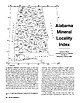
 | | Journal (article/letter/editorial) | | I I 34° MARIOH 34° I LAMAR , v:I G'l Alabama Q, \'l'I Q, 33° 0 1- I I I (/) ";lO ...Geological Survey of Alabama P.O. Box 0 Tuscaloosa, Alabama 35486 85° • County Seat ALABAMA'S MINERAL...iron furnace was built near Russellville, Franklin County, utilizing local brown iron-ore (goethite) deposits...Tennessee River Valley area near Huntsville, Madison County, the first such mineralogical description in the...the Coosa River (Chilton County). Utilization of mineral resources in Alabama has long been a significant |  | | Journal (article/letter/editorial) | | GRAPHITE DEPOSITS OF ASHLAND, ALABAMA? JOHN S. BROWN. CONTENTS. Introduction .....................themetamorphic rocks ................................ Graphite ...................................................... Massive graphite andgraphite veins ................................. Graphite inTalladega slate...belt. 2 Two areas,the moreimportantone entirelyin Clay • Society of EconomicGeologists,New York Meeting...Surv.of Alabama, •923, PP. t3, 98. 208 GRAPHITE DEPOSITS OF ASHLAND, ALABAMA. 209 County,the other |  | | Report (issue) | | DIVISION OF CONSERVATION DEPARTMENT OF MINES, MINING AND GEOLOGY GARLAND PEYTON, Director THE GEOLOGICAL...DIVISION OF CONSERVATION DEPARTMENT OF MINES, MINING AND GEOLOGY GARLAND PEYTON, Director THE GEOLOGICAL...li LETTER OF TRANSMI'ITAL Department of Mines, Mining and Geology Atlanta, December 19, 1951 To His...value to petrologists, structural geologists and mining geologists. It is our belief that the publication...Definition Quartzite Biotite Gneiss Mica Schist _ ___ Graphite Schist Marble Little River Series ___ _ Definition |  | | Report (issue) | | Strategic Graphite A Survey By EUGENE N. CAMERON and PAUL L. WEIS CONTRIBUTIONS TO ECONOMIC GEOLOGY...___________________-__--_---__------__--____________ The graphite problem--__-_____-----------------_---_._____...occurrence of natural graphite._-_.._._.___ Minerals associated with various types of graphite.____________________...production.________________________ Geology of graphite deposits in the United States__-_._________--...deposits in carbonate rocks._________________ Graphite resources and reserves.__________________________________ |  | | Journal (article/letter/editorial) | | ans THORNTON L. NEATHERY GeologicalSurveyof Alabama,P.O. Box O, UniversityStation,Tuscaloosa, Alabama35486...metamorphosed submarinebasalts and felsicrocksof the Ashland,Wedowee,andTalladegalithotectonicterranes.Thesethree...modelsto explain variousmineral occurrencesin Ashland,Wedowee, and Talladegalithotectonicter- Newfoundlandwith...1. Generalized geologic map of the Tailadega, Ashland, and Wedowee terranes of the southernmost Appalachians...Georgia. The rock assemblages of the Talladega,Ashland, lachiansmayrepresentmineralizationin a transitory |  | | Report (issue) | | .. . .......... ... ................. Shale and clay . . . . . . . . . . . . . . . . . . . . . . . ..... . . . . . . . . . . . . . . . . . . . . . . Graphite . . . . . . . . . . . . . . . . . . . . . . ..... . . . . . . . . . . . . . . . . . . . . . . . Clay ................................................... . . . . . . . . . . . . . . . . . . . . . . Graphite. . . . . . . . . . . . . . . . . . . . . . . .... . . . . . . . . . . . . . . . . . . . . . . . Clay, sand and gravel, and fill material . . . . . . |  | | Report (issue) | | aie! BARTLETT'S/27 FERRY FAULT } i GEORGIA ALABAMA sy .i % OP A iar an waeew ows mp ede eel (...CAROLINA ug 5; “A BARTLETT'S/.2 FERRY FAULT ? ALABAMA GEORGIA 50 . Lee 50 MILES SO KILOMETRES UNIVERSITY...this volume on the sulfide deposits of Georgia-Alabama. from does It has been the authors not involve...Appalachians in Paleorift the Southern Flank Alabama (Robert W. of Turkey Haven Schafer and J. Settings...Copper Anomaly at the Peachbottom Deposit, Alleghany County, North Carolina (John E. Callahan, J. Hatten Metal |  | | Journal (article/letter/editorial) | | xled—crystallized ALABAMA — William M. Johnson, R.F.D. 6, Knoxville, Tenn., sends in a note on graphite in Alabama...Alabama. Flake graphite, he writes, occurs in the Ashland schist as a belt extending through Clay, Coosa and...maximum width of the Ashland schist is about 4 miles extending N.E. to S.W. and the graphite occurs in lenses...composed of quartz, muscovite or sericite, pyrite and graphite with small amounts of feldspar in certain places...operation but by 1940 all but one had closed. This graphite is used in making crucibles. One of the major |  | | Report (volume) | | ......................................... 5 Alabama......................................................................................... 102 District of Columbia ....................................more extensive deposits of some others, such as clay, coal, and iron ore, are mentioned only in general...to refer to Geological Survey Bulletin 507, "The mining districts of the western United States," and to...abundant it may have been completely exhausted by mining or quarrying. Deposits of minerals that are widely |  | | Report (issue) | | deposit. Table 4, part B, gives an alphabetic list of mine and properties followed by the deposit name. CHARACTERISTICS...deposits used in Table 1 may represent a major mine, district name, or local town name or other prominent... Pyrrhotite appears to be been reported in just a single mine in the East Belt of the Sierra Nevada foothills...(Malcolm, 1912), galena was widely considered by mine operators to be correlated with better gold grades...was described in a carbonate quartz veinlet in one mine in the Mother Lode system (Knopf, 1929). Method |  | | Report (volume) | | more extensive deposits of some others, such as clay, coal, and iron ore, are mentioned only in general...each of the States, the State lists begin with Alabama and end with Wyoming. Under each State the minerals...it helpful to refer to Survey Bulletin 507, "The mining districts of the western United States," and to...abundant, it may have been completely exhausted by mining or quarrying. Deposits of minerals of wide distribution...because they occur in sufficient quantity to warrant mining for their usual products but because they furnish |  | | Book (edition) | | YEAR 1687"—DAVID T. DAY, CHIEF OF THE DIVISION OF MINING STATISTICS AND TECHNOLOGY WASHINGTON GOVERNMENT...and consump tion, or better and cheaper means of mining, extraction, and convey ance to market, may in...correspondence has been carried on with geologists, mining engineers, and other local authorities, and various...together. 9194 MIN 44 690 MINERAL RESOURCES. ALABAMA—Mined. Mineralogical name. Coal, var. bitu minous...mmed at Broken Arrow aud Trout creek, in Sc. Clair county. The strata in this field are more faulted und |  | | Journal (article/letter/editorial) | | CLEBURNE COUNTY, ALABAMA1 TnonNroN L. Noarnnnu, GeologicalSuraeyof Alabama, Uniaersity, Alabama. ABSTRACT...11 E., at Turkey Heaven Mountain, Cleburne County, Alabama, discloseda unique mineral occurrence.The mineral...WedoweeFormation, a highly resistant graphite-mica schist, and 2) a unit of the Ashland Mica Schist,an extensivelyweathered...Wedowee Formation over-liesthe Ashland Mica Schist. The resistant graphite-micaschist of the Wedowee Formation...of the area. The general regional strike in the Alabama crystalline belt is about N. 45o E., and the dip |  | | Report (issue) | | #92-568 by: Jeffrey R. Levine The University of Alabama, Tuscaloosa and Jane R*. Eggleston United Stated...Kuhn Library, University of Maryland, Baltimore County) (Note: This and other historical photos appearing...#92-568 by: Jeffrey R. Levine The University of Alabama, Tuscaloosa and Jane R. Eggleston United Stated...Kuhn Library, University of Maryland. Baltimore County) (Note: This and other historical photos appearing...Geology ...................................... 34 Mining and Labor History............................. |  | | Book | | : =: n 1871, shortly after the University Alabama reopened by Federal returned of after its...Alabamians. he accomplished transformed became Alabama the from What catalyst that an aimless and...“Little Doc,” as told in Eugene Allen Smith’s Alabama, sources: Smith’s is drawn from many transcribed...histories of the state and of the University of Alabama, and contemporary newspapers. How he accomplished...lush EUGENE ALLEN SMITH’S ALABAMA EUGENE ALLEN SMITH’S ALABAMA How a Geologist Shaped a State |  | | Report (issue) | | _________________ _ Wedowee formation ____________________ _ Ashland mica schist ____________________ _ Volcanic series...Georgia ___________________________________ _ Alabama __________________________________ _ Younger rocks...__________________________________ _ History of mining ________________ ·__________________ _ Production...34 35 35 36 39 44 44 45 46 47 47 49 49 50 50 Mine descriptions ___________ --------- -- .. -------...___ _______________________ _______ _ Fauquier County ____ ______ ______ _____ _____ _ Franklin ____ |  | | Report (issue) | | Four areas of peridotite near Murfreesboro, Pike County, Ark., were known at the time of the writer's visit...1908, pp. 187-194. Fuller, J. T., Diamond mine in Pike County, Ark.: Eng. and Min. Jour., vol. 87, 1909...C., and Brackett, E. N., The peridotite of Pike County, Ark.: Am. Jour. Sci., 3d ser. vol. 38, 1889, pp...thinner. It consists of intercalated beds of marly clay, sand, gravel, and limestone. The principal bed...consists of intercalated beds of gravel, sand, and clay. The gravel occurs in several beds throughout the |  | | Report (volume) | | Notes on the gold lodes of the Carrville district, Trinity County, Cal., by D. F. MacDpnald...............account of the ore deposits of the Loon Creek district, Idaho, byJ. B.Umpleby................................................. Notes on the Antelope district, Nev., by F. C. Schrader................... Notes...Notes on the northern La Sal Mountains, Grand County, Utah, by J. M. Hill. Survey publications on gold............... COPPER: The Turquoise copper-mining district, Ariz., by F. L. Ransome........... Survey |  | | Book | | Mines SP Mining and Mineral in the South-Central] Operations States B80TIAT(G ge’ MINING AND MINERAL...cataloged as follows: United States. Bureau of Mines. Mining and mineral operations in the South-Central States:...and nonmetallics. Stable and economic domestic mining, mineral, metal, and mineral reclamation industries...enjoy your experiences. This pamphlet, a guide to mining and mineral operations that may be observed or...aid tourists and students who are interested in mining. Some may wish to study our Nation’s romantic past; |  | | Report (issue) | | Geological Survey of Alabama, University, Ala. Department of :ty.lines, Mining and Geology State Division...Jr ___________________________ _ Relationship of mining to other economic sectors, by Albert E. Schreck...Manmade features _____________________ _ Strip mining ______________________ _ Subsidence ________________________...___ _ Resource potentiaL ____________________ _ Clay, by John W. Hosterman, Sam H. Patterson, J()hn W...Introduction __________________________ _ Miscellaneous clay and shale ____________ _ Types and occurrence ______________ |  | | Journal (article/letter/editorial) | | Bedrosian United States Geological Survey, Denver, CO, USA a r t i c l e i n f o Article history: Received...attributed to metallic sulfides, and in some cases, graphite. The former is a potential source of sulfur for...system has been postulated to extend as far as Alabama (Steltenpohl et al., 2013) along the Fort Wayne...basins such as the Twin Cities basin in MN, the Ashland syncline in MN/WI, and the Stratford basin in IA...the north of the Niagara fault zone (Sternberg and Clay, 1977; Yang et al., 2015). 4. Methods 3D magnetotelluric |  | | Journal (article/letter/editorial) | | North America; the rare earth pegmatitesb of Llano County (Texas), Minas Geraes(BraziI), Ytterby (Sweden)...2, pp. 104-105, 1907. la Reid, A. Mclntosh, The mining fields of Morina, Mt. Claude, and Lorinna: Tasmania...pp. 300-311. t6 Dolmage, Victor, Finlay River district, British Columbia:' Canad'ian l[i'n. TH E AM...A. L Genesis of mica pegmatite deposits, Latah County, Idaho: , Econ. Geology,vol. 28, no. 1, pp. 41-58... 20Barrell, Joseph, Geology of Marysville mining district, Montana: U.S. Geol,. Suntey, Prof . Paper |  | | Book (volume) | | quarries in the western counties, especially the Clay Center Quarry 12 miles southeast of Toledo but in...ASHTABULA COUNTY CONNEAUT, area pits, quarries, rd. cuts, etc.⎯cone-in-cone Calcite. CLERMONT COUNTY MILFORD...CLINTON COUNTY WILMINGTON, area of Todd’s Ford, a mineral deposit⎯Hematite. COSHOCTON COUNTY AREA, townships...CUYAHOGA COUNTY CHAGRIN FALLS (on Geauga Co. line), area quarries⎯oilstone. DELAWARE COUNTY DELAWARE...exposures of blue clay, as clusters and nodules⎯Pyrite (crystals sharply cubic). FRANKLIN COUNTY COLUMBUS, area |  | | Report (volume) | | Gulch-Deadwood district _______________ Whiskeytown district ______________________ Shasta-Redding district _____________________...Dog Creek (Delta) district __________________ Bully Choop (Indian Creek) district _______________ Harrison...Harrison Gulch district ______________________ Hayfork district ___________________________ Minersville...Minersville district __________________________ Trinity Center district ________________________ Canyon Creek-East...Creek-East Fork district _________________ 28 29 30 32 33 37 38 38 38 39 40 41 42 42 43 43 44 45 46 49 in |  | | Journal (article/letter/editorial) | | similar lithologically to gneisses in Calaveras County, California, and those near Shoup and Elk City...found near the headwaters of Wagner Creek west of Ashland, at Starling Peak still farther to the west, and...Mountain, Creek, (24) Jurassic; Eocene;(33) Bald Mine, Kane '49 Pliocene; (I)(5)River, Tyee, (14) Oligocene;...in California appears to grade upward through a graphite and actinolite schist to the hornblende schist...batholith at the California-Oregon boundary south of Ashland. This intrusive is of a much later date and possibly |
|


